We relaxed outside Bangor for two nights before heading to Acadia National Park – both to break up the drive and to minimize our campground cost (the campground near Acadia doesn’t accept our discount club on weekends). We walked around the campground, I caught up on the blog, Charlie flew his drone and we planned for Acadia National Park.

")
The short drive from Bangor to the park ended well – we managed to get better than expected deals on both a campground and a rental car. There are so many low overpasses in the park that driving the RV to explore just isn’t practical (on top of the unhooking each morning and hooking up again at the end of the day). We ended up with a Mustang convertible – not our choice but all they had available and we got it for about half its normal rate (close to what I’d found online for a compact car). For a while it was odd to be so low to the ground – we’ve gotten used to being up high and having a huge windshield.
Before picking up the rental car we drove to the Visitor Center to get tips on where to go and what to see. Unfortunately the road is all torn up just before you get to the park entrance – no fun in the RV. We received several good suggestions of places to see – especially for good photos. As we left we asked if there was an alternate route that we could use to avoid the mess – unfortunately the ranger must have forgotten about a 12′ overpass (we’re about 12’6″ or 12’8″) so we had to retrace our path and endure the road work again.
Our campground is not in the park or even on Mount Desert Island – but just over the bridge across the Narrows. The season is just beginning and there are only a few other campers here so we can see the water from our campsite and it is nice and quiet. The pricier (non-discounted) campsites are on the water – and they have quite a view!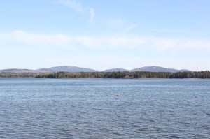
After breakfast we loaded up the car with maps, camera equipment, hiking equipment and everything we should need. Rather than get on the Park Loop Road as soon as we got to the park we decided to drive into Bar Harbor first. The road construction stretches from just before the park entrance all the way into town – really glad to be in a car instead of the RV. There are some beautiful churches in town as well as all the touristy shops you can imagine. The roads are narrow and there is very little parking – we would hate to be here in July when tourists are everywhere!
")
")
We parked by the marina and got a few more pictures – it was low tide and the sandbar that connects Bar Island with Bar Harbor was exposed but we opted not to make that hike. Then we left town and got on the Park Loop Road at approximately the point at which we had to turn back due to that low overpass the previous day.
There are many overlooks and scenic stopping points along the Loop Road – we stopped at a few but couldn’t see very far due to fog just off the coast. The sea gulls are seemingly without fear of humans – in areas where picnics are popular the signs warn that sea gulls will steal your food if you turn your back! There are some amazing houses along the coast – you can see the fog just beyond this one at Schooner Head.
")
")
Sand Beach is the only beach on the island’s coast with sand rather than rocks and boulders – so it is a popular spot. It was very windy the day we were there so few people were spending much time on the beach – blowing sand isn’t fun. I’m not sure I’d ever want to swim here – they claim the water gets to around 55 degrees in the summer but that’s too cold for me! From the parking lot we could see Beehive Mountain – I was afraid the hike would be too difficult for me so we didn’t attempt it.
")

Our next stop was at Thunder Hole – water rushes in a narrow slot and crashes into the rock causing a thunderous sound and large splash.
")
")
")
Then a hike up Gorham Mountain was next – about a one mile hike with a moderate rating. At the trailhead we found signs indicating that part of the trail was closed for trail maintenance and we would have to take the Cadillac Cliffs trail for a portion of the way – it is a section of climbing over boulders and along what used to be sea cliffs (when the ocean level was higher). I made it just to where the boulder climbing began – and it was too much for me so I waited while Charlie continued to the top for some pictures. Whisps of fog came close to the trail so it is not surprising that the views at the top were limited – although Sand Beach could be seen through the fog.
")
")
")
Next stop was Otter Point (and a quick stop at Otter Cliffs) for a much more typical rocky “beach” area. I like sitting back and watching the waves crash over the boulders; Charlie climbs out on the rocks as far as he can to get pictures!

")
")
After Otter Point the Loop Road curves around Otter Cove then back out to Hunters Head – but the fog was so heavy that we didn’t stop. Then we followed the road inland to Jordon Pond – the restaurant is not open yet for the season or we could have stopped for their famous tea and popovers! We did stop at the parking area just past the restaurant and walked down to the water for a view of North and South Bubble. Later as the road passed closer to the Bubbles we were able to get a view of Bubble Rock – a boulder left perched on South Bubble by glaciers.


Just before the end of the Loop Road we took the side road to the top of Cadillac Mountain – at 1,530 feet it is the highest point on the east coast of the United States and a great place for sunrise and sunset viewing. We were several hours before sunset but the view to the west from the Blue Hill Overlook near the top is amazing!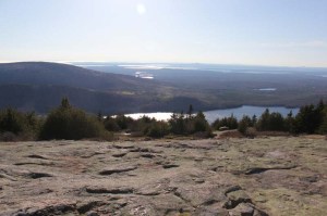 And the views from the top – even with a lot of fog still to the east and south – were impressive. I love this shot of Bar Harbor and the fog coming in between the various Porcupine Islands.
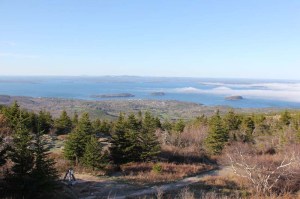 Back down the mountain we continued on the Loop Road to the alternate route back to the RV avoiding the road construction at the park entrance.
Next day we headed for the western side of Mount Desert Island – hoping that the fog would not make an appearance. We passed through several small towns on our way to the southwestern end of the island and the Bass Harbor Head Lighthouse. A wrong turn led us to this lovely church where we turned to get back on track.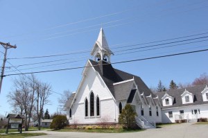 There are two places to see the lighthouse from – you can walk around to the beach and look up from the rocks or you can walk around the keeper’s house right up to the base of the lighthouse. Charlie was able to climb out onto the rocky beach and get great views but I had to wait until we walked around to the base to see it.
")
")
Our hopes for the fog lifting obviously were not met so our hike of the Wonderland Trail was less than ideal but it was a nice walk to a great birdwatching area.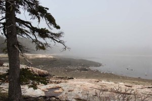
As we continued north we passed deer in a few places – one was nibbling grass in a person’s yard and others crossed the road in front of us then began nibbling the grass beside a lobster pound.
")
")
Then we drove through the town of Southwest Harbor and the whole way around Somes Sound to the town of Northeast Harbor where we walked through Asticou Azalea Garden. The azaleas are just barely beginning to bloom – but it is still a lovely peaceful spot.
")
")
")
Before we left for the day we made one more attempt for great views from the top of Cadillac Mountain but the fog was still hanging off the east and south. So we headed back to the RV to unload the car and fill the gas tank before returning it. A dinner of lobster stew at Lunt’s Gateway Lobster Pound (just as good and not as much work as a whole lobster) rounded out our day!
We spent one more day just relaxing at the campground – figuring out where to go next and housekeeping a bit. Then we headed west for our next adventure!
For many more pictures and three videos (1 at Thunder Hole and 2 at Otter Point) of our visit to Acadia National Park – click here.

Acadia is one of our favourite national parks. Looks like you had nice weather when you visited (minus the fog situation). What was the name of the campground you stayed at? Sounds beautiful if you could see the water from your campsite.
LikeLike
Yes – other than the fog the weather was pretty good. The campground was Narrows Too – an Encore/Thousand Trails Resort – right next to the Bar Harbor Airport. They accepted the Passport America discount club that we belong to for the days we were there so that really helped on the cost. If the campground had been full we probably couldn’t have seen the water from our RV – but since we were gone most days exploring the park it made more sense to get a discounted site not on the water.
LikeLiked by 1 person